Welcome to the Israeli Theater Airports diagrams project for Falcon BMS 4.36.
You can find a sub-menu tabs in yellow color at the top of this page, for easy access to each parts of this project.

Note: If you print this PDF file, it will be resized for your printer and may not be the exact same size as my PNG file. If you need to test a PNG file, go to my DOWNLOAD section.
Airport diagrams for (ITO) Israel Theater

Airport diagrams in PDF format are available here.
To download all PDF and PNG files, go to the «Download» page (Yellow Download Menu Tab here) and download the entire package Zip file.
 (INFO) Airport Diagram Legend (PDF Format). Last update: 2022-02-19 09h45am.
 Ben_Gurion_airport.pdf") (LLBG) Ben_Gurion Airport Diagram (PDF Format). Last update: 2022-02-19 09h45am.
(LLBG) Ben_Gurion Airport Diagram (PDF Format). Last update: 2022-02-19 09h45am.
 Eilat_airport.pdf") (LLET) Eilat Airport Diagram (PDF Format). Last update: 2022-02-19 09h45am.
(LLET) Eilat Airport Diagram (PDF Format). Last update: 2022-02-19 09h45am.
 Hatzerim_airport.pdf") (LLHB) Hatzerim Airport Diagram (PDF Format). Last update: 2022-02-19 09h45am.
(LLHB) Hatzerim Airport Diagram (PDF Format). Last update: 2022-02-19 09h45am.
 Hatzor_airport.pdf") (LLHS) Hatzor Airport Diagram (PDF Format). Last update: 2022-02-19 09h45am.
(LLHS) Hatzor Airport Diagram (PDF Format). Last update: 2022-02-19 09h45am.
 Meggido_strip.pdf") (LLMG) Meggido_strip Diagram (PDF Format). Last update: 2022-02-19 09h45am.
(LLMG) Meggido_strip Diagram (PDF Format). Last update: 2022-02-19 09h45am.
 Navatim_airport.pdf") (LLNV) Navatim Airport Diagram (PDF Format). Last update: 2022-02-19 09h45am.
(LLNV) Navatim Airport Diagram (PDF Format). Last update: 2022-02-19 09h45am.
 Ovda_airport.pdf") (LLOV) Ovda Airport Diagram (PDF Format). Last update: 2022-02-19 09h45am.
(LLOV) Ovda Airport Diagram (PDF Format). Last update: 2022-02-19 09h45am.
 Palmachim_airport.pdf") (LL59) Palmachim Airport Diagram (PDF Format). Last update: 2022-02-19 09h45am.
(LL59) Palmachim Airport Diagram (PDF Format). Last update: 2022-02-19 09h45am.
 Palmachim_airport_Wide.pdf") (LL59) Palmachim Airport Diagram (PDF Wide Format). Last update: 2022-02-20 08h00am.
(LL59) Palmachim Airport Diagram (PDF Wide Format). Last update: 2022-02-20 08h00am.
 Ramat_David_airport.pdf") (LLRD) Ramat David Airport Diagram (PDF Format). Last update: 2022-02-20 08h00am.
(LLRD) Ramat David Airport Diagram (PDF Format). Last update: 2022-02-20 08h00am.
 Ramat_David_airport_Wide.pdf") (LLRD) Ramat David Airport Diagram (PDF Wide Format). Last update: 2022-02-20 08h00am.
(LLRD) Ramat David Airport Diagram (PDF Wide Format). Last update: 2022-02-20 08h00am.
 Ramon_airport.pdf") (LLRM) Ramon Airport Diagram (PDF Format). Last update: 2022-02-19 09h45am.
(LLRM) Ramon Airport Diagram (PDF Format). Last update: 2022-02-19 09h45am.
 Ramon_airport_Wide.pdf") (LLRM) Ramon Airport Diagram (PDF Format). Last update: 2022-02-20 08h00am.
(LLRM) Ramon Airport Diagram (PDF Format). Last update: 2022-02-20 08h00am.
 Rosh_Pina_strip.pdf") (LLID) Rosh_Pina_strip Diagram (PDF Format). Last update: 2022-02-19 09h45am.
(LLID) Rosh_Pina_strip Diagram (PDF Format). Last update: 2022-02-19 09h45am.
 Sde_Dov_airport.pdf") (LLSD) Sde Dov Airport Diagram (PDF Format). Last update: 2022-02-19 09h45am.
(LLSD) Sde Dov Airport Diagram (PDF Format). Last update: 2022-02-19 09h45am.
 Tel_Nof_airport.pdf") (LLEK) Tel Nof Airport Diagram (PDF Format). Last update: 2022-02-19 09h45am.
(LLEK) Tel Nof Airport Diagram (PDF Format). Last update: 2022-02-19 09h45am.
In the «Download» tabs, you can download the most current package (All PDF and PNG files in one ZIP file).
ITO Israel SID and AIC diagrams will be added soon in the next month (this work is already started).
Later, all others ITO airports for all other ITO Theater country (Egypt, Saudi Arabia, Syria and so on...) will also be completed.
All current ITO Israel airport diagrams are created from a vector illustration software (Adobe Illustrator).
Here is some technical informations (may be modified in further updates):
- 1) The RUNWAY WIDTH will be modified soon (when exact runway data will be available to diagrams author).
- 2) «ARP GPS» info on header diagram will be based on first CONTROL TOWER positionning and ARP pictograms will be removed from all airport diagrams in further updates.
- 3) Some airbases have a VOR/DME pictograms, other are using VORTAC or TACAN. Some pictograms will be fixed or updated as soon as SID and IAF project will start.
- 4) Magnetic North Variation is real life information as on febuary 2022.
- 5) FAA pictogram for TWR (Control Tower) with a beacon have different meaning upon offical documents. Author will use the FAA Flight information publication instrument approach procedures and airport diagrams (IAC-4) in next diagram update.
- 6) PAPI lights on the airport diagram are removed and these informations will appear on approach plate (IAC) diagrams on further update.
- 7) The Tacan Channel (TCN CHN Ex: 099X) will be added inside the box where TACAN pictogram are displayed. Some VOR/DME vs TACAN vs VORTAC pictograms will be fixed as soon more detailled informations will be provided by the DEV TEAM.
- 8) Wider diagrams with Magnetic North properly aligned on top are also available in "paysage" page format where filename is terminated by a "_Wide" label.
FAA: Interagency Air Committee Specifications (IAC Main page)
FAA: Interagency Air Committee Specifications (IAC Main page)
FAA: Sectional Aeronautical And VFR Terminal Area Charts (IAC-2)
FAA: Sectional Aeronautical And VFR Terminal Area Charts (IAC-2)
FAA: Flight information publication instrument approach procedures and airport diagrams (IAC-4)
FAA: Flight information publication instrument approach procedures and airport diagrams (IAC-4)
FAA: Nellis Air Force Base Airport Diagram (KLSV)
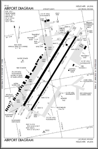
FAA: Nellis AFB airport diagram (KLSV)
Magnetic Declination
Magnetic Declination in Israel
![]() ITO Theater BMS 4.36 Airport Diagrams - Full Package (Last update: 2022-02-20).
ITO Theater BMS 4.36 Airport Diagrams - Full Package (Last update: 2022-02-20).

 HNE, GMT-5).